words by Evan Thayer
Winter is once again on our doorstep in Utah with fresh snow already falling on our mountains. Palpable excitement has been building in the ski and snowboard community, as it always does this time of year. Last season, we saw above-average snowfall across the state – a fantastic encore to the record snowfall in 2022–23. Now, many are wondering if it is possible we could go for the hat-trick of three consecutive 'good' seasons. Well, I'm here to take a hard look at what we are seeing, and then, what that could mean for our winter.
Firstly, I want to reiterate that seasonal forecasts are hard. They are so difficult, in fact, that I typically don’t like to use the word "forecast" in association with an entire season. It implies some type of certainty. In actuality, the only certainty in seasonal forecasting is uncertainty. In Utah, there just isn't much correlation between El Nino La Nina or any other known atmospheric or oceanic condition that would guarantee us a good or bad year. With that said, let's dive into what we could see in this winter outlook.
ENSO Cycle
ENSO, or El Niño Southern Oscillation, is the scientific term for the phases of the ocean sea-surface temperatures that translate to El Niño or La Niña events. Most of us are familiar with these terms, but may not know the specifics. Essentially, there is a relatively small area of water in the central Pacific Ocean that is known to have a great influence on the weather patterns in the Northern Hemisphere. Warmer-than-average temperatures at the surface of the ocean in this region mean we are in an El Niño event. Conversely, cooler-than-normal water temperatures mean La Niña.
After a weak La Niña in 2022–23, we went to a moderate-to-strong El Niño last season. As we know, Utah did extremely well in that weak La Niña, but also did fairly well in the subsequent El Niño.
This year, we are moving back toward La Niña. NOAA gives us a 75% of reaching La Niña conditions by the time we move into the heart of winter: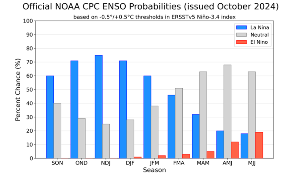
However, not all El Niño/La Niña events are created equal. Not only can each event have its own oceanic signature, but you can also see weak, moderate, or strong events of each. The strength of the event can have a large impact on the effects as well.
This year, we are currently forecasted to see just a weak La Niña event.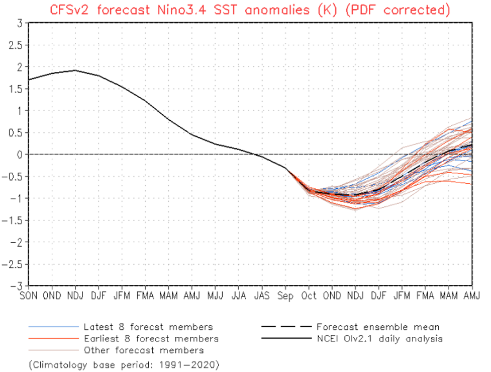
You can see that the mean of the forecast models show our ONI index (the measure of ENSO temperature/strength) bottoming out around -1.0C. That is still considered a weak event.
For forecasting purposes, let us now check analog years -- or years in which we also had weak La Niña conditions. This may give us the best sense of how we may do. Over the past 30 years, there are six previous winter seasons that had weak La Niña events ongoing.
-
2000–01
-
2005–06
-
2008–09
-
2016–17
-
2017–18
-
2022–23
Using these seasons as guidance, let's look at how we fared.
Since Alta Ski Area has the best individual resort snowfall data and is also centrally located to many other resorts in Utah, I am going to start by looking at their numbers in these seasons. Here is how they did for seasonal snowfall: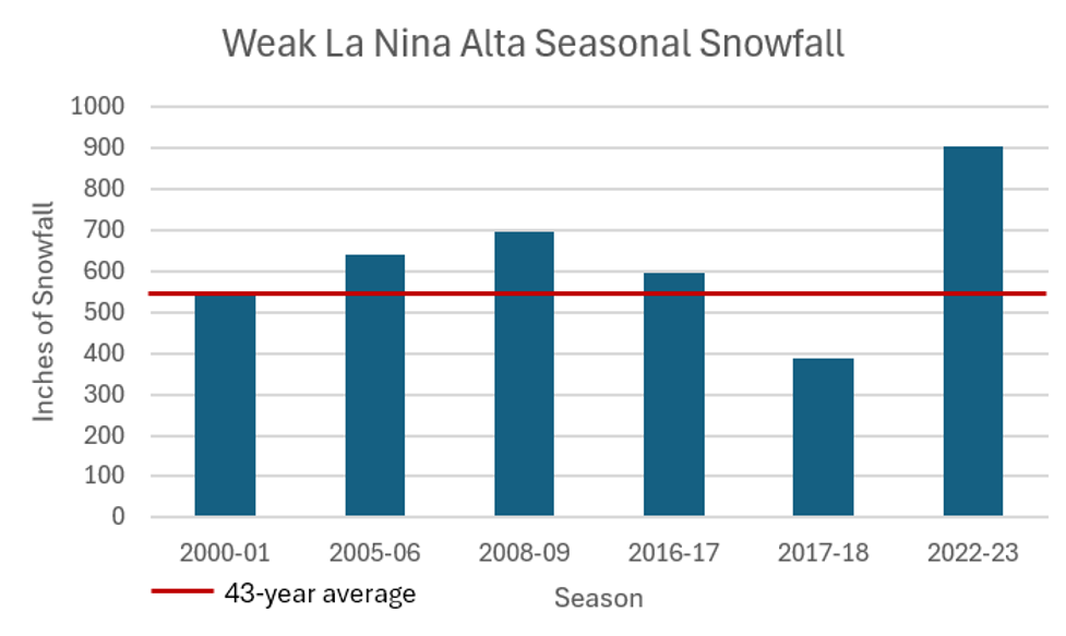
I also added the red line to indicate the 43-year average of 546" of snow. You can see that 2000–01 was just about average. We then have three solidly above-average years in 2005–06, 2008–09, and 2016–7. Then, we had a well-below-average season in 2017–18. Lastly, we have the record-breaking 2022–23 season which dropped a famous (infamous?) 903" of snow at Alta. Obviously, this last year may skew our data a bit since this is a small sample size.
However, taking this all into account, we have an average of 629" of snow in weak La Niña seasons which is 115% of normal.
Statewide, we also have a general lean toward above-average seasons. You can see each of these seasons graphically compared to the statewide median snowpack (smooth lime green line):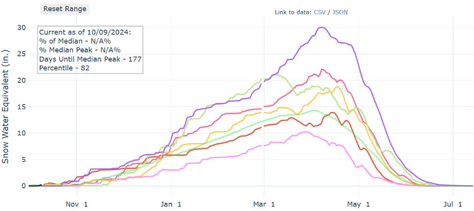
Like Alta, we have one year solidly below normal (2017–18). One year right about average (2000–01). Then, four years above average.
Zooming out on the entire west, we can also get a feel for how these six winters performed in other regions:
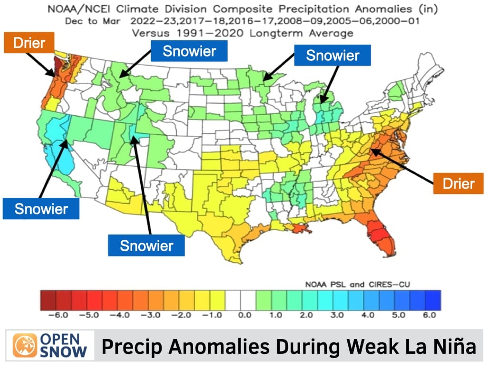
You can see that California and the Intermountain West did particularly well. Contrary to what you might expect in a stronger La Niña, the Pacific Northwest actually has lower-than-normal precipitation anomalies.
As for temperatures, this is what we saw in the temp anomalies during these six winter seasons:
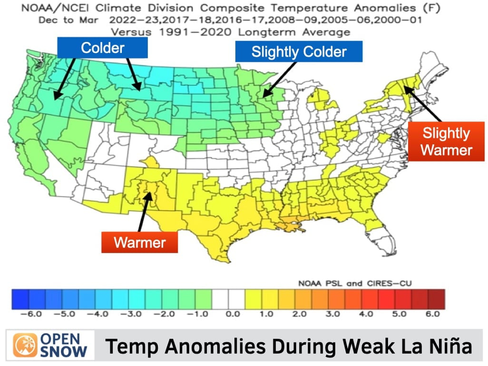
Around average temperatures for Utah with cooler-than-normal temperatures to our north.
Other Factors
Of course, there are other factors that could influence our weather aside from just ENSO. There is growing interest in the QBO (Quasi-biennial Oscillation) and its impacts on snow in the west. While it's hard to use this as a predictor of anything, I can say that its current phase is generally considered to be favorable for snow in the western states.
There will also be other teleconnections such as the MJO (Madden-Julian Oscillation). However, these are more temporal and move through their respective phases throughout the winter and tend to lead to short or medium-range patterns rather than seasonal ones. We will just have to hope the MJO spends plenty of time in favorable stages this winter.
Conclusion
Again, none of this is a guarantee of anything. At best, you are just ever-so-slightly loading the dice in your favor. Anything can happen and after two above-average winters in a row, perhaps we are due to be at or below-average. Who knows? While I like to explore the possibilities, it's not typically worth expending too much effort on seasonal forecasting, especially in Utah. Hope for the best and be ready for anything. One thing is for certain, Utah will get a lot more snow than most places! We always do.


