Written by Wasatch Snow Forecast:
On Tuesday, November 15, 2016, there was palpable concern in the Utah ski community. Our mountains were devoid of snow, with Alta having received only 4 inches of snow in October and early November. Several ski resorts had announced they would be pushing back their opening dates due to the lack of early season snowpack. To say we were desperate is an understatement.
Luckily, there was hope in the forecast as a pattern change was taking place for the second half of November. I remember urging folks to be patient—just a single good storm could get us back on track. In my years in Utah, I’ve learned that winter always delivers if you’re patient. Sure enough, we went on to receive an additional 70” of snowfall at Alta over the last two weeks of November. This active pattern was able to jumpstart our winter ski season in Utah, and the rest, as they say, is history.
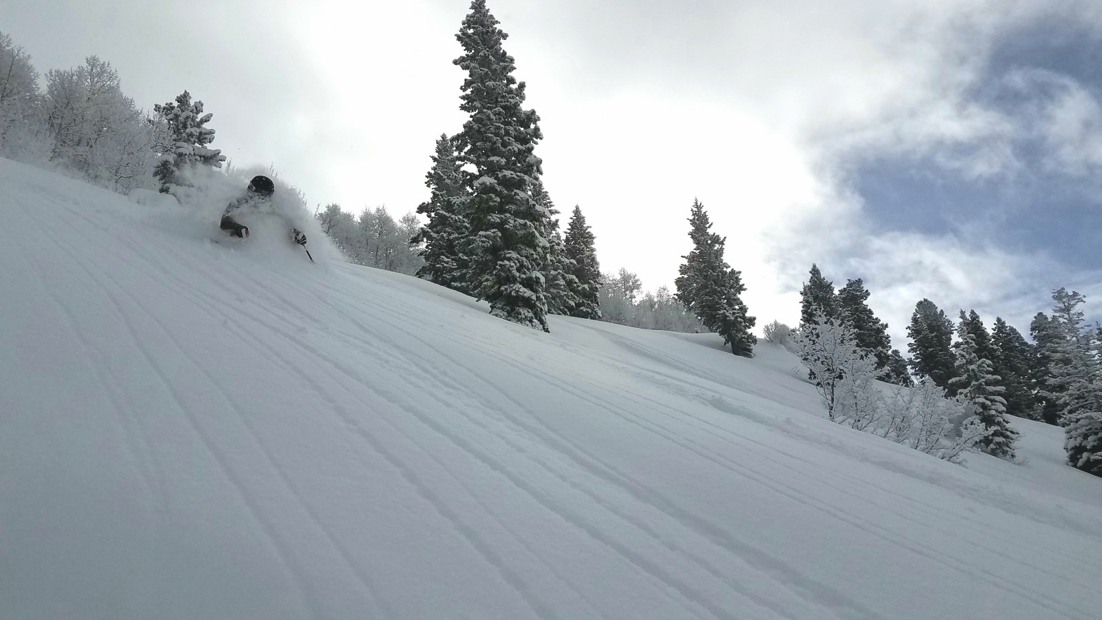
December saw a continuation of the stormy pattern. For the 3rd consecutive year, the week between Christmas and New Year’s Day was a powder feast. I took this photo of my friend Kyle at Powder Mountain on December 26th after nearly 3 feet of blower powder:
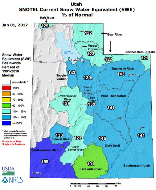
Heading into the New Year, we were sitting pretty, with every basin in Utah reporting above average snowpack on January 1, 2017:
Who would have guessed that was only the beginning? January featured two HUGE storm cycles that dropped record snowfall throughout much of the state. Persistent southwest flow favored locations such as Brighton and Deer Valley Resort, both of which saw record snowfall amounts during the month of January.
February started rather quietly, but we ended the month with another epic storm cycle that dropped FEET of snowfall in the Wasatch Range of Northern Utah. Most locations saw yet another above average month. Snowpack numbers at the end of February were staggering, with every single basin in the state reporting well-above average numbers.
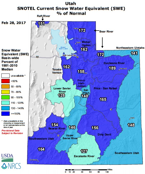
December, January, and February were all very snowy months that featured a seemingly endless stream of powder days. It wasn’t until March that we returned to reality. High pressure finally took control and we saw 3 weeks of drier weather and warmer temperatures. March probably killed our chances of making a run at the seasonal record books, but even so, the end of season snowpack numbers are impressive statewide. It is without question, the best winter we’ve had since 2010-11.
At Snowbird, we have spent almost all season with a well-above average snowpack:
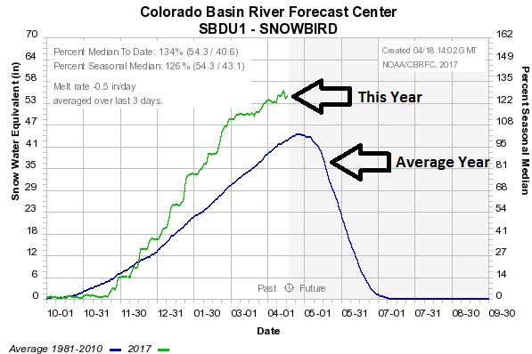
It is even more impressive when you compare this season to the previous 5 years…
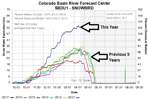
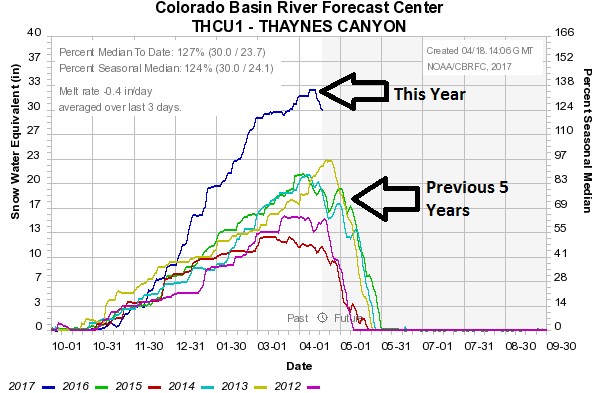
Our snowpack is nearly double the mean from the previous 5 years at this same time! Park City Mountain has had similarly impressive season:
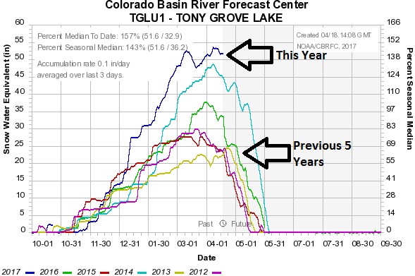
Up north, Tony Grove Lake near Beaver Mountain also had their best season in more than half a decade:
And down south, Midway Valley near Brian Head Ski Resort also pulled in impressive numbers:
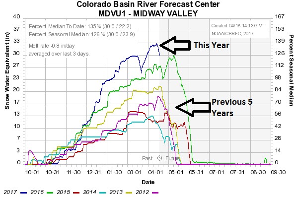
What made this season so special was that everybody was a winner – from the Idaho border to the red rock of southern Utah, all mountain locations saw above average snowfall. There was, however, one resort that pulled in numbers significantly higher than others. Brighton Resort, in Big Cottonwood Canyon, has reported an incredible 632” of snowfall this season thus far. As we mentioned earlier, Brighton had a monster January with over 200 inches of snowfall in that month alone. They have been the beneficiary of unusually strong and prolonged periods of moist southwesterly flows. The topography surrounding Brighton favors the area in this type of pattern. Deer Valley is another resort favored by this SW flow, and Deer Valley also broke seasonal snowfall records this year because of it.
"So if you call Brighton or Deer Valley your home resort, then you can feel particularly blessed this season. Ultimately, however, it’s hard for any of us to feel aggrieved. We came back from our slow start to have what is certainly our best winter season for quite some time."


